


DESIGNED FOR REAL WORK
DoRare — water-level monitoring and flood warnings for agencies and local authorities
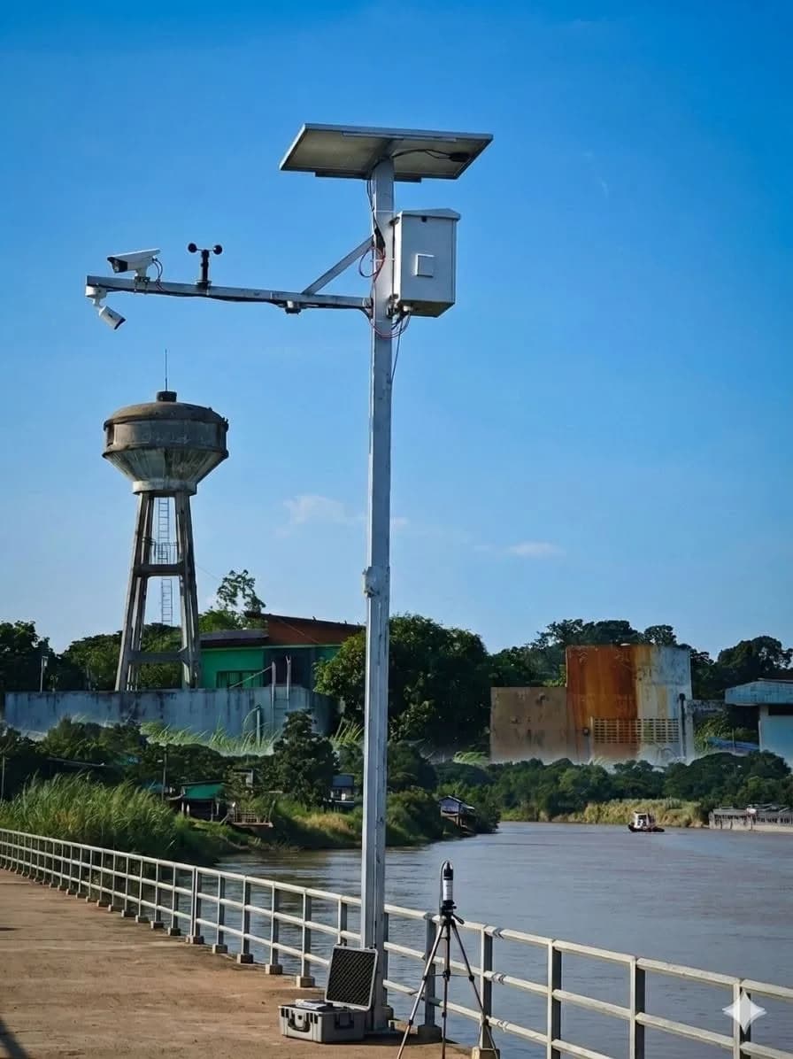
DoRare monitors water levels and issues flood warnings for government agencies, local authorities and riverside areas. It combines 80 GHz radar with an AI camera reading a staff gauge, so readings can be checked against actual images. DoRare comes in 2 forms: DoRare Station, a complete solar-powered station, and DoRare View, a monthly service that reads existing CCTV. In 2026, we installed DoRare Station at the listed 20 riverside locations across 4 provinces in Thailand for flood monitoring.
Should you choose DoRare Station or DoRare View?
Choose DoRare Station where a risk location has no measuring point, electricity or network cabling. The kit combines radar, a camera, solar panels, batteries and 4G. The installation needs 4G mobile coverage, with an agency LAN port as a backup option.
Choose DoRare View if the agency already has CCTV with a clear view of a staff gauge by day and night. Send sample images so we can assess whether AI can read them. If the existing cameras cannot see a staff gauge, DoRare View cannot be used; start with DoRare Station.
DoRare Station
DoRare Station is a complete water-level station for 1 location with no electricity or network cabling but with 4G coverage. The kit includes water-level radar, a backup level sensor for cross-checking, a rain gauge, weather sensors, an AI camera reading a staff gauge, solar panels, a LiFePO4 (lithium phosphate) battery and 4G. During signal loss, the station stores data locally according to the specifications below; we confirm this for the proposed model before quoting. The per-location price includes surveying, installation, training, a data SIM and cloud service for the first 2 years.
Prepare before discussing: Installation locations and photos, number of locations, and local communications coverage
From THB 250,000 per station (including VAT)
Request a Station site assessmentDoRare View — monthly software service
DoRare View is a monthly software service (SaaS) that uses AI to read water levels from an agency's existing CCTV and sends threshold alerts without installing a new station. The entry package supports 100 readings/day. Cameras must clearly show a staff gauge by day and night. Before starting, we review sample images and how the system can access them to confirm that AI can read the gauge.
Prepare before discussing: Camera images showing the gauge by day and night, and how to access those images
From THB 5,500 per month
Assess existing cameras for ViewHow does DoRare measure water levels and send alerts?
Measure water levels and capture images
Radar measures water levels without touching the water, a backup sensor provides a separate reading, and a camera photographs the staff gauge. DoRare View uses images from the agency's existing CCTV.
AI reading and cross-checking
AI reads the staff gauge in the image and compares it with the sensor reading. Station specification v5 calls for staff notifications when the readings differ. Actual images appear beside AI readings and are retained for 90 days for staff review. We confirm this function for the proposed model before installation.
Send data to the dashboard
Under station specification v5, the station sends data over 4G and adjusts reporting intervals to the hazard level. During signal loss it stores data locally and uploads all backlogged records when the connection returns. Model-specific availability is confirmed before quotation.
Notify staff and activate warnings
Station specification v5 specifies LINE or email alerts and relay control of warning equipment such as public-address systems. Available channels, response times and relays must be confirmed for the proposed model.
Who is DoRare for, and where is it unsuitable?
Municipalities and local administrative organisations
DoRare Station suits community risk locations such as sluice gates, branch canals and underpasses beneath bridges. It can activate existing public-address systems. Residents can subscribe to community alerts through the agency's LINE account and view data on a public web page or via QR Code. The control cabinet must sit at least 1.5 metres above the highest flood level in the past 10 years. If this is not possible at the risk location, choose a new installation position.
Water management agencies
Water management agencies use DoRare to view all stations on one map, compare historical graphs across stations, export CSV or Excel and connect existing systems through REST API (an interface for exchanging data with other systems). The software runs in the cloud and stores data in Thailand. If data must be held in the agency's own system, retrieve it through REST API or exported files.
Factories and riverside sites
Riverside factories with existing CCTV that can see a staff gauge can start with DoRare View without installing a new station. If the cameras cannot clearly show the gauge both day and night, DoRare View is unsuitable; use DoRare Station.
Technical specifications — DoRare Station
Figures are minimum requirements in DoRare station specification v5 (August, Buddhist Era 2569). DoRare View uses the agency's existing CCTV and requires no additional hardware.
| Version | DoRare Station uses the InSensor processing unit (X1 board) in the model specified for the project · DoRare View is SaaS (a monthly software service) |
|---|---|
| Field processing unit | InSensor (X1 board), K210 (RISC-V) chip, RT-Thread OS; built-in web configuration with tools for calibrating the reference level against a staff gauge; watchdog reset on system freeze; 3 power modes based on battery charge; automatic cabinet cooling fan activation at 45 degrees Celsius |
| Sensor connection ports | RS485 (Modbus RTU): at least 2 ports · 4–20 mA: at least 4 channels · Digital/Pulse: at least 4 channels |
| Warning equipment control | Station specification v5: at least 4 dry-contact relay channels rated at 5 A to control public-address towers, wired speakers, signal lights or warning siren poles, plus a 12 V LED rotating beacon at the station |
| Water-level sensors | Non-contact radar, 0.5–15 metre range, ±10 mm accuracy, IP67 · Backup sensor (pressure or ultrasonic), 0–10 metres, for cross-checking |
| Weather sensors | Tipping-bucket rain gauge, 0.2 mm resolution · Temperature, humidity and atmospheric pressure |
| Camera and AI | 4 MP IP camera, IP66, infrared range at least 30 metres, supporting ONVIF Profile S, RTSP and H.265/H.264; reads a 3-metre reflective staff gauge; sends images every 30, 5 or 1 minute according to hazard level; retains images for 90 days |
| Energy | 200 W solar panel · 20 A MPPT solar charge controller · 12.8 V 100 Ah LiFePO4 (lithium phosphate) battery — at least 7 days of operation without sunlight at normal reporting intervals (minimum requirement), with no mains electricity connection |
| During signal loss | Stores data locally for at least 30 days, automatically uploads backlogged records when the signal returns, and triggers threshold-based warnings independently without waiting for the centre |
| Communications | 4G LTE with an external antenna of at least 5 dBi gain and LAN backup · Station specification v5: MQTT with TLS 1.2 or higher encryption; sends data every 15, 5 or 1 minute according to hazard level |
| Anti-theft kit | Cabinet opening, pole tilt or vibration, and under-panel motion sensors trigger a photo, lighting and an alert within 60 seconds of an event |
| Operating conditions | Processing unit: -10 to 60 degrees Celsius; relative humidity up to 95 percent, non-condensing |
| Structure and installation | Galvanised steel pole at least 4 inches in size and 6 metres high, with a concrete foundation at least 0.6 × 0.6 × 0.8 metres, or mounted to a bridge pier/sluice gate · Control cabinet at least 1.5 metres above the highest flood level in the past 10 years |
| Optional modules | PM2.5/PM10 particulate matter · Ultrasonic wind measurement · Water quality (conductivity and salinity) with replaceable cartridges |
| Cloud software | Map of all stations · 4 alert levels (normal/watch/warning/critical) · LINE/email alerts within 60 seconds · Images alongside AI readings · Rate of water rise and time to the next threshold · Historical graphs with CSV/Excel export · Public web page + QR Code · Summary report every 6 months · REST API (interface for exchanging data with other systems) |
Station kit contents (Flood model, per 1 location)
The station kit is factory assembled, configured and tested, with the cloud account and data SIM already activated. Higher models add the modules shown in the price table.
- Field control cabinet with InSensor (X1 board), keys and a cabinet opening sensor
- Non-contact water-level radar, configured and calibrated
- Backup water-level sensor for cross-checking, with a 15-metre cable
- Tipping-bucket rain gauge with a leaf screen
- Temperature, humidity and atmospheric pressure sensors in a sun- and rain-protected enclosure
- 4 MP IP camera with mounting bracket and power control circuit
- 4G/LTE communications kit with antenna and a data SIM for 2 years
- Reflective reference staff gauge, 3 metres long
- 12 V LED rotating beacon with cable and control circuit
- 200 W solar panel with adjustable mounting bracket
- 20 A MPPT solar charge controller and 100 Ah LiFePO4 (lithium phosphate) battery fitted in the cabinet
- Surge protection equipment and grounding kit
- Anti-theft kit (cabinet opening, pole tilt and under-panel motion sensors)
- Cloud software service for 2 years, unlimited users and 90-day image retention
- Station sign with QR Code and a QR sign file for community display
- Thai-language manual, installation instruction card and handover documents
The per-location price includes the station pole, foundation, survey and design, installation and calibration, and staff training.
Warranty and after-sales service
- 2-year warranty covering both hardware and software service
- Send repairs to the service centre in Nonthaburi. Repairs are completed and returned within 7 working days, with free loan equipment during repair.
- Solar panels and batteries are replaced by sending a new unit first and collecting the original afterwards, so the station does not have to wait for the original unit to be repaired.
- Preventive maintenance by the local installation provider under its contract with the agency
- Commitment to continuous spare-parts supply for at least 5 years
Excludes damage from installation that does not follow the manual, lightning where the specified protection system was not installed, equipment modification and theft.
Preparation and operating conditions
DoRare Station installation site
- A position where the camera can see the full staff gauge and the cabinet can be installed at least 1.5 metres above the highest flood level in the past 10 years
- Local 4G coverage, tested by the local installer during the survey, or an agency LAN port
- A local benchmark or reference station for calibrating water levels against mean sea level
- The agency applies for site-use permission. The local installation provider prepares documents, drawings and technical information within the agreed scope.
Software and data
- Use a web browser on computers and mobile devices without installing an app; no limit on the number of users within the agency
- Stored in a data centre in Thailand, with automatic daily backups and 1 year of backup retention
- All data belongs to the agency, in accordance with Thailand's Personal Data Protection Act, 2019
- If cloud service is not renewed, the station continues to measure, store data locally and activate threshold-based warnings as usual.
DoRare View
- CCTV cameras with a clear view of a staff gauge by day and night
- A means for the system to access camera images; the team assesses sample images before use
DoRare Station package pricing
Prices include VAT for 1 installation location, surveying, installation, training, a data SIM and cloud service for the first 2 years. Request a quotation for annual service fees from year 3.
Flood
Complete flood warning system with anti-theft kit
250,000 THB
Flood + Air
Adds PM2.5 and PM10 particulate matter sensing
280,000 THB
Flood + Air + Wind
Adds ultrasonic wind speed and direction sensing
320,000 THB
Flood + Water
Adds cartridge-based water quality sensing with 2 cartridge sets and 2 years of exchange service
380,000 THB
Packages by installation count
Request a quotation for multiple-location packages and monitoring centre kits.
Works using this product
View all projects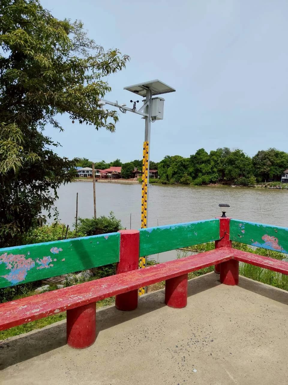
Download station specifications
FAQ
Will the station keep working through several days without sunlight?
Yes. The station specification requires a 100 Ah LiFePO4 (lithium phosphate) battery to power the system for at least 7 days without sunlight at normal reporting intervals. As charge falls, the field processor in the cabinet automatically lengthens reporting intervals to save power, and the system alerts when energy drops below the threshold. Crisis Power Management is a separate crisis-saving mode that lets sensors operate for 1 month without sunlight by reducing their operating frequency, so it differs from normal reporting intervals.
What happens if the 4G signal is lost?
The station continues measuring and stores at least 30 days of data locally, then uploads all backlogged data when the signal returns. Meanwhile it can independently activate public-address systems or rotating beacons according to the agency's thresholds.
What are the costs in later years, and what happens if service is not renewed?
Data SIM and cloud fees for the first 2 years are included in the station price. Annual fees from year 3 are stated in the quotation. If service is not renewed, the station continues measuring, storing data locally and activating warnings as usual. Staff can download data through an on-site connection. Renewing restores cloud access immediately without another initial setup fee.
Who owns the measured data?
All data belongs to the agency and is stored in a data centre in Thailand. It can be exported as CSV or Excel. At the end of the contract, raw data and image files are handed over within 30 days at no extra charge.
Do camera images affect residents' privacy?
DoRare reduces the impact in 3 ways: aiming cameras only at waterways and public areas, reducing public web image resolution so individuals and vehicle registration plates cannot be identified, and placing recording notices at installation sites.
Where has DoRare Station been installed in practice?
In 2026, we installed DoRare Station at the listed 20 riverside locations across 4 Thai provinces for a private company that commissioned flood-monitoring work. We learned that cameras must clearly show the staff gauge and each station's scale must be calibrated before AI reading begins. Your project should therefore start with a list of risk locations and coordinates, followed by camera-angle surveys and 4G signal tests at each location. See the case study of 20 water-level stations across 4 provinces in the projects using this product section.