




20 DoRare water-level monitoring stations for riverside flood monitoring in 4 Thai provinces
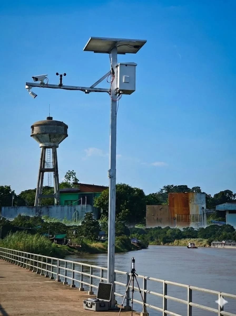
This project installed 20 DoRare Station water-level monitoring stations along rivers in 4 provinces of Thailand in B.E. 2569, allowing operators to view images and water-level readings from every site on a single web dashboard. Cameras photograph water-level gauges for AI to read approximately every 15 minutes, and the system sends LINE or email alerts when water levels reach the thresholds.
- Industry
- Government and water management
- Year
- 2026
- Scope of work
- Supply and assembly of 20 DoRare Station control cabinets (codes CAB-001 to CAB-020; 5 include a weather station), web dashboard development, on-site installation and preparation of a user manual, for the private company that commissioned the work.
Summary
- We installed DoRare Station at the 20 listed riverside locations in 4 provinces of Thailand in 2026.
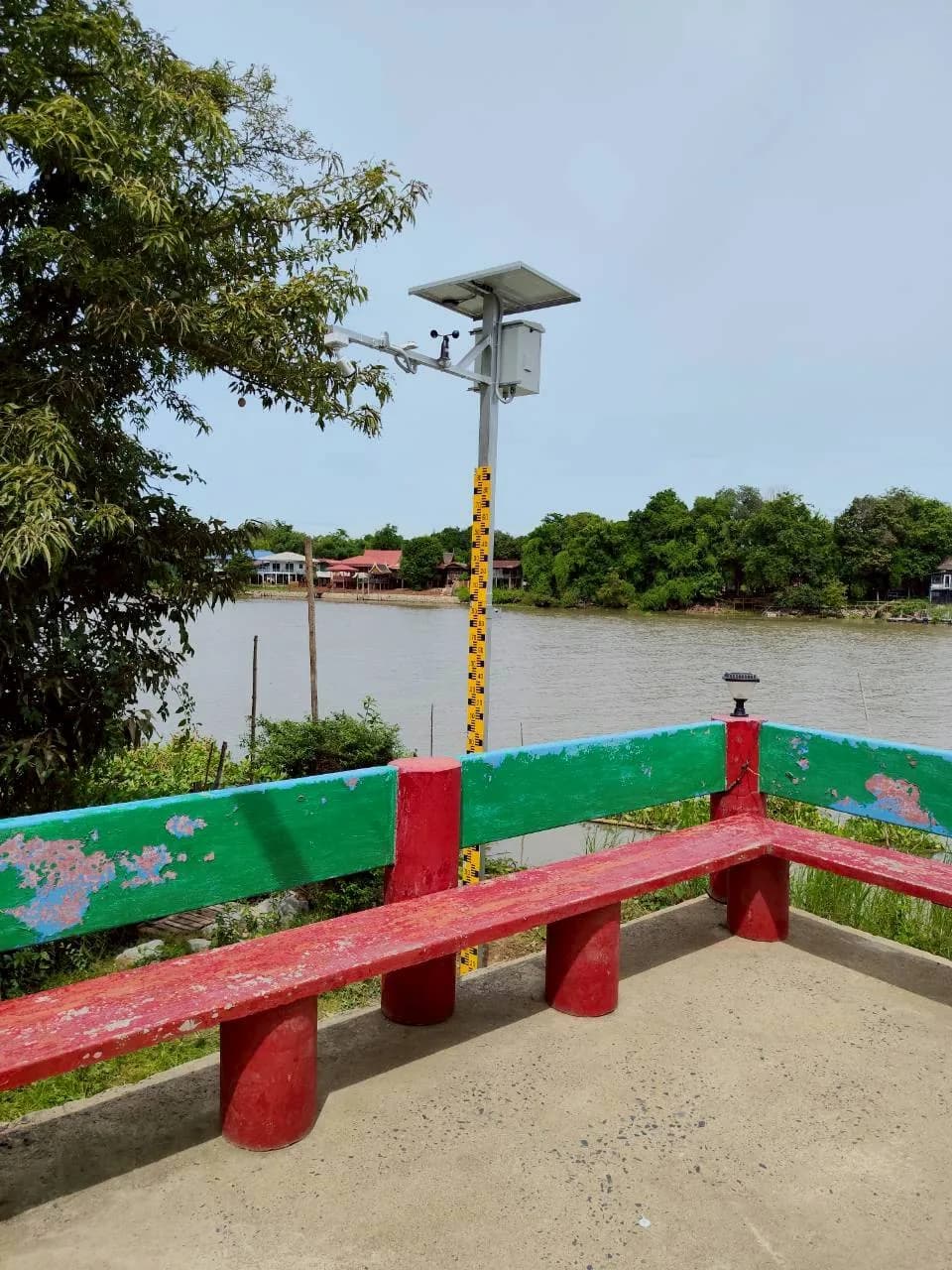
- Each station measures water level in 2 ways: a camera photographing the water level staff gauge for AI to read approximately every 15 minutes, and a radar water level sensor.
- Every cabinet runs on solar panels with a LiFePO4 battery and sends data through a 4G router with a SIM card, so installation sites need no power or network cabling.
- The DoRare web dashboard shows a map, camera images, water level history and cabinet condition for every station, and sends 3-level alerts by LINE and/or email.
- We prepared a system user manual and issued a 24-month hardware and software warranty.
The on-site brief
Traditional water monitoring was slow and incomplete because the monitoring points are spread across riverside communities in several districts in 4 provinces. Operators wanted to see water levels and actual images from every point in one place, so they could identify locations at risk of flooding in good time.
What we did
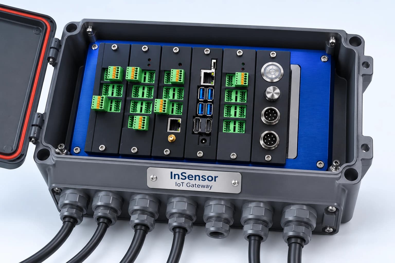
We installed 20 DoRare Station control cabinets powered by solar panels and sending data through 4G routers. Each cabinet measures water level in 2 ways: an IP camera photographs a staff gauge for AI to read, and a radar sensor is connected to InSensor (X1 Board). Data from every point goes to the DoRare web dashboard, which sends 3-level alerts by LINE and/or email.
- Radar water level sensor+ weather station, at locations that have one
- InSensor (X1 Board) in the DoRare Station cabinetReads sensor values; solar + battery power
- 4G router + SIM cardIP camera sends images directly to the router over a LAN cable
- DoRare web dashboardAI reading of water levels from images
- LINE / email alerts
Results
We installed cabinets at the 20 listed locations in 2026, prepared a system user manual and issued a 24-month hardware and software warranty. Operators can view images and water levels for every station from a web browser.
Measured results
- Water level monitoring stations in the system
- 20stations
- Image and water level update interval (approximate)
- 15minutes
How the brief came about
The challenge in this case was to see water levels at 20 monitoring points in 4 provinces from one place. These points are in riverside communities across several districts, so traditional water monitoring was slow and incomplete. Operators wanted to identify locations at risk of flooding in good time.
Operators wanted water levels and actual images from every point on a single map. Water levels show which points are starting to reach the watch threshold, while camera images are used to check water levels by eye and are kept as evidence to support the readings.
What is a staff gauge?
A staff gauge is a wooden staff or scale plate set in a body of water, marked with levels in centimetres. People normally read it by eye. In this case, a camera photographs the gauge and AI reads the water level mark from the image.
Requirements and constraints
Every cabinet has to operate outdoors by the river, powered by solar panels and a battery and sending data via SIM card, so no power or network cables need to be run to the installation site. The main requirements in the proposal document are as follows.
- Powered by solar panels and a battery, sending data over the mobile network by SIM card
- A camera for checking water levels, with still images recorded as evidence
- 5 designated locations must have a weather station measuring temperature, humidity and rainfall
- Operators must be able to see cabinet condition remotely (temperature, humidity, air pressure, battery, fan and router) and select the cabinet's power mode
How each station measures water level
Each station measures water level in 2 ways. The first is a radar sensor that gives a numerical water level reading. The second is a camera photographing the staff gauge for AI to read. Camera images also let operators check water levels by eye and are kept as evidence to support the readings.
For power and networking, we chose cabinets powered by solar panels and LiFePO4 batteries, sending data through 4G routers, in line with the job requirements. Each station works as follows.
- 1
Photographing the staff gauge and measuring by radar
The IP camera at each station photographs the staff gauge, while the radar sensor measures water level separately. Locations with a weather station also collect temperature, humidity and rainfall.
- 2
InSensor reads sensor values
InSensor (X1 Board) in the cabinet reads values from the radar sensor and weather station (where fitted), then forwards them to the 4G router. The IP camera connects to the router by LAN cable and sends images directly to the central system, not through InSensor.
- 3
Sending data through the 4G router
Images and measured values go to the central system via SIM card. The cabinet status page shows how much SIM data has been used and how much remains.
- 4
Reporting cabinet condition and selecting the power mode
The control cabinet reports its internal condition (temperature, humidity, air pressure, battery, fan, router) to the Monitor System page. Operators can choose from 4 power modes: Normal, Save, Full Power and Plan Mode, which schedules operating times in advance.
- 5
AI reads values and displays them on the dashboard
The system uses AI to read water levels from the staff gauge images approximately every 15 minutes, then displays them on the station map and water level history table, alongside camera images. Operators can export the history as a CSV file for further reporting.
- 6
Alerts based on each station's thresholds
System administrators set 3 threshold levels separately for each station. When the water level reaches the critical threshold, the system sends alerts by LINE and/or email as configured. The system can also send equipment notifications, such as a camera going offline or a low battery.
What we built and installed
We supplied and assembled 20 DoRare Station control cabinets, developed the web dashboard, carried out on-site installation and prepared a user manual. The main items are as follows.
- 20 control cabinets, codes CAB-001 to CAB-020, each with an IP camera, radar water level sensor, InSensor (X1 Board), solar panel, LiFePO4 battery and 4G router
- 5 weather stations, installed in designated cabinets
- DoRare web dashboard: station map, camera images, water level history exportable as CSV files, Monitor System page and 4 power modes
- 3-level alerts (normal/watch/critical) with thresholds set separately for each station, sent by LINE and/or email
- Viewing through a web browser, with separate permissions for system administrators (Admin) and general users (Viewer)
- Scale calibration of each station's staff gauge, by dragging the upper and lower points to match the marks on the gauge and entering values in centimetres
- System user manual, and a 24-month hardware and software warranty
Confirmed results
We installed DoRare Station cabinets at the 20 listed locations in 4 provinces in 2026, and have site photographs for all 20 locations, organised by location name. Operators can view images and water levels for every station from a web browser, with images and water levels updated approximately every 15 minutes.
We prepared a system user manual and issued a 24-month hardware and software warranty. This case does not yet have figures measuring usage results, so we report only what is confirmed by documentation.
What we learned
This work offers 3 principles for unattended field measurement stations.
- Values read from images should have the original image stored alongside them. In this work, staff gauge images serve both as data for AI to read and as evidence for people to check by eye, and each station also has a radar sensor measuring separately.
- Field equipment must also report its own condition, not just measured values. In this work, operators can see the battery, fan, router and SIM data of every cabinet, and receive alerts when a camera goes offline or a battery is low.
- Settings must be tied to the station, not a single value for the whole system. Each location has its own staff gauge and camera position, so scale calibration and 3-level alert thresholds are set separately for each station.
How this approach can apply to your site
If your agency looks after several water level monitoring points without electricity or network cabling, you can use the same approach as this case: solar-powered cabinets, data sent via SIM, water level measured from images and radar, and all points combined on one dashboard. What needs adjusting is the camera position, calibration values and thresholds for each location.
Reusable parts and parts that need adapting
| System part | Reusable | What needs adjusting |
|---|---|---|
| Power and data transmission | Cabinets powered by solar and battery, sending data through a 4G router | If the installation site has weak or no mobile signal, a site survey is needed before choosing the location |
| Water level measurement | Camera photographing the staff gauge, paired with a radar sensor | If the camera cannot see the staff gauge clearly, choose a new camera position and calibrate the scale separately at every station |
| Weather station | Add only at locations that need temperature, humidity and rainfall data | Set the number and positions of weather stations according to the data your area needs |
| Alerts | 3-level thresholds set per station, with alerts sent by LINE and/or email | If critical levels or the people responsible differ from this case, thresholds and the alert recipient list must be redefined |
| Dashboard | Map, images, value history exportable as CSV, and Admin/Viewer permissions | Prepare a list of users and assign Admin or Viewer permissions to each person |
- Prepare the location name, address and latitude/longitude coordinates of every station from the outset, so cabinet codes can be matched correctly to positions on the map
- Estimate monthly SIM data usage for each cabinet before choosing a package, because the system regularly sends images to the central system
- Plan long-term maintenance of field equipment, especially batteries, solar panels and power mode selection during periods of low sunlight
Read more
- DoRare Station: water level and weather measurement station
- InSensor: field sensor data collection device with an X1 Board inside
- Field system and equipment installation service
- System care and maintenance service
- Prototype case: Edge AI reading water meter dials
- Article: How flood warning systems work for Subdistrict Administrative Organisations and municipalities
Technology used
Frequently Asked Questions
How does the system read water levels from images?
A camera photographs the staff gauge, then AI converts the water level position in the image into a water level reading approximately every 15 minutes. Before use, the system administrator calibrates the scale by dragging the upper and lower points to match the marks on the gauge and entering values in centimetres. Each station also has a radar water level sensor as a separate measurement.
Does the installation site need electricity or internet?
No power or network cabling is needed. Every cabinet runs on solar panels with a LiFePO4 battery and sends data through a 4G router with a SIM card. However, the installation site must have mobile signal, so a site survey should be done first.
What can the system send alerts about?
The system sends alerts when the water level reaches each station's critical threshold, and can also notify about equipment, such as a camera going offline, a low battery, high temperature inside the cabinet or SIM data running low. Operators can turn alerts on or off per cabinet and choose LINE and/or email.
Do I need to install a program to view the data?
No. You can view it directly in a web browser. Administrators (Admin) can configure stations, alert thresholds and users, while general users (Viewer) can only view dashboards, reports and cabinet status.
How much does it cost to install in another area?
The per-station price of DoRare Station is on the product page. For projects with multiple sites or on-site installation work, please request a quotation from us. Our assessment is based on the number of sites, site conditions and network signal.