




Mobile digital navigation for a public educational campus (KMITL)
Organisation: King Mongkut's Institute of Technology Ladkrabang
This mobile digital navigation system for KMITL was commissioned under a 2026 contract. Users can find buildings, service points and events, then follow campus routes step by step. We have invoiced both 2 installments and submitted the final deliverable. Acceptance results are currently awaiting confirmation.
- Industry
- Government
- Year
- 2026
- Scope of work
- Work under the contract in 2 parts, a mobile navigation app and an introductory web page: place search, section-by-section walking routes, nearby service points, travel information within the institute, and activities by building
- Duration
- Contract dated 24 July 2026 · Final-instalment delivery submitted August 2026
Summary
- The digital navigation system submitted for delivery to KMITL has 2 parts: a mobile navigation app and an introductory web page. Users can find buildings, service points and activities within the institute on their own.
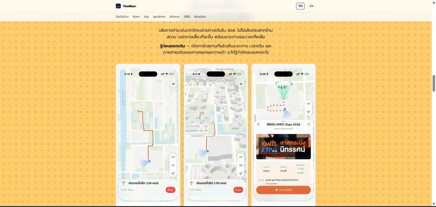
- The app calculates routes from the walkway network within the institute, then gives directions section by section with distance and walking time, rather than a straight line drawn across the area.
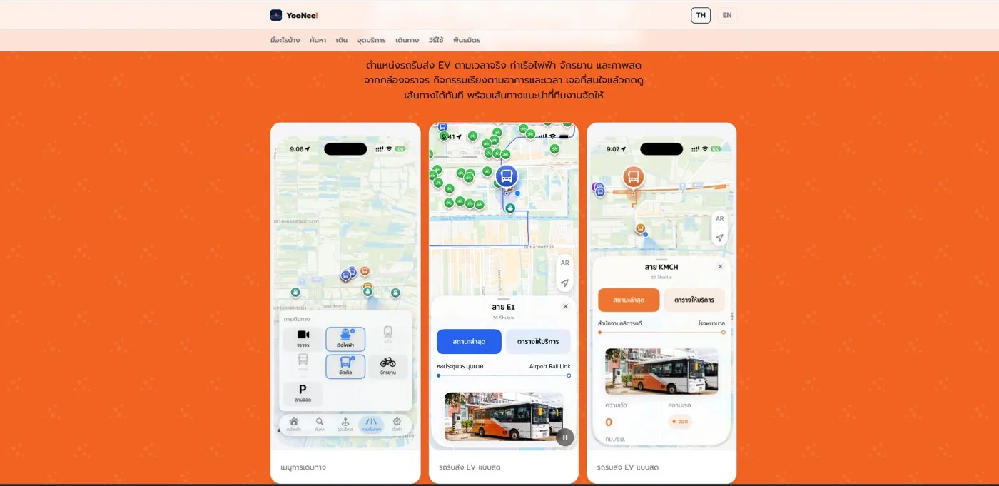
- The app brings together nearby service points, such as AEDs, ramps and lifts, with travel information within the institute, such as real-time electric shuttle (EV) positions and live images from traffic cameras, in a single app.
- We have invoiced the 2 instalments and submitted the final-instalment delivery letter in August 2026. Confirmation of the acceptance result and of the scope of revisions required is now in progress.
- This approach can be used for universities and other large multi-building sites, but it must start from walkway and service-point data that the site's administrators have checked.
The on-site brief
On a large site with many buildings, people unfamiliar with the area may need to ask for directions or search for service points several times. The work under this contract is to develop a digital navigation system within the KMITL site, so that users can search for places and plan walking routes themselves from a mobile phone.
What we did
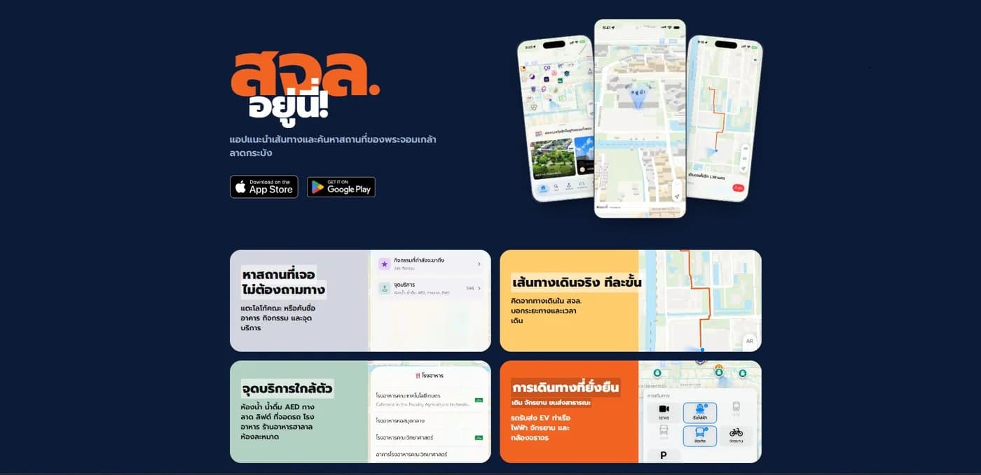
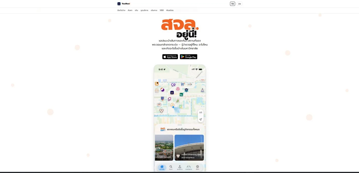
The delivery has 2 parts: a mobile navigation app and an introductory web page. The app calculates routes from the walkway network within the institute, then gives directions section by section with distance and walking time. It also shows nearby service points and travel information within the institute in a single app.
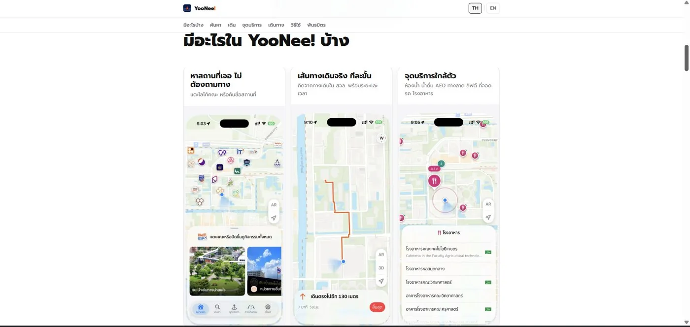
- Find a locationTap a faculty logo or type a name
- Calculate routes using campus walkways
- Step-by-step directionsDistance, walking time, entrance photo
- Live travel informationEV shuttles and traffic cameras
Current status
We have invoiced the 2 instalments and submitted the final-instalment delivery letter with system screenshots in August 2026. Confirmation of the acceptance result and of the scope of revisions required is now in progress.
How the brief came about
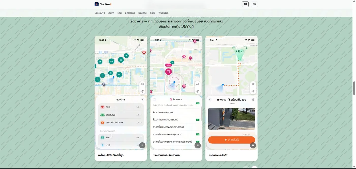
The challenge in this case is helping people unfamiliar with the site to find buildings, service points and activities within the institute on their own from a mobile phone. On a large site with many faculties and buildings, visitors may need to ask for directions or search for service points several times. The app therefore shows key service points such as AEDs (automated external defibrillators), ramps and lifts.
The contract for developing the digital navigation system within the KMITL site is dated 24 July 2026, and delivery is divided into 2 instalments.
How does on-site navigation (wayfinding) differ from a general map?
General maps focus on public roads, whereas an on-site navigation system uses walkway, building and service-point data specific to that place, so it can take users more directly to a building entrance or service point.
Requirements and constraints
The system must work on mobile phones and must use the institute's own site data. The main requirements and constraints are as follows.
- Delivery of 2 parts: a mobile navigation app and a web page introducing the system's capabilities
- Delivery under the contract, divided into 2 instalments
- Data on buildings, service points and internal walkways must be checked jointly with the site's administrators before use
- Real-time data, such as shuttle positions and traffic camera images, requires a source the system can connect to
Why does this system calculate routes from the institute's internal walkways?
This system calculates routes from the institute's internal walkway network because users want to reach a building entrance or service point, not merely the road in front of the building. The route is therefore one that can actually be walked, section by section, rather than a straight line drawn across the area. The app gives the distance and walking time of each section.
On reaching the destination, users need to know they are in the right place, so the place card shows real photos of junctions and entrances, letting users compare the image on screen with what they see in front of them. The steps of use are as follows.
- 1
Search for a destination
Tap a faculty logo on the map, or type the name of the building, activity or service point you want to go to.
- 2
View the place card before setting off
The card shows distance, walking time and real photos of junctions and entrances, so you know what to look for on arrival.
- 3
Follow the route section by section
The app shows the distance remaining in each section, and you can switch to a 3D map view or AR (the route overlaid on the image from the phone's camera).
- 4
Find nearby service points
Bring up nearby toilets, drinking water points, AEDs, ramps, lifts, car parks or canteens, then tap to continue navigating.
- 5
Choose how to travel within the institute
See real-time electric shuttle (EV) positions, piers, bicycles and live images from traffic cameras to help you decide how to travel.
Deliverables
The system we submitted for delivery has 2 parts: a mobile navigation app and an introductory web page, with system screenshots supporting the final-instalment delivery. The app's capabilities are divided as shown in this table.
Capabilities of the system in this delivery
| App section | What users can do |
|---|---|
| Find a location | Tap a faculty logo or type the name of a building, service point or activity |
| Walking routes | Follow the institute's internal walkways section by section, with distance, walking time and photos of junctions and entrances |
| Nearby service points | Find toilets, drinking water points, AEDs, ramps, lifts, car parks and canteens |
| Travel within the institute | See real-time EV shuttle positions, piers, bicycles and live images from traffic cameras |
| Events | View activities by building and time |
| Map views | Switch to a 3D map view or AR |
How far has delivery of this work progressed?
This work has been submitted for delivery, and confirmation of the acceptance result is in progress. We have invoiced the 2 instalments and submitted the final-instalment delivery letter with system screenshots in August 2026. The scope of revisions required is still awaiting confirmation with the client.
- 24 July 2026: date of the contract
- August 2026: invoiced the 2 instalments and submitted the final-instalment delivery letter with system screenshots
- Current status: confirmation of the acceptance result and of the scope of revisions required is in progress
We are not yet reporting user numbers or usage results because there is no acceptance result yet. What this case describes is therefore the system's capabilities as submitted for delivery.
What we learned
This work offers 3 principles for navigation systems within large sites.
- Routes must come from that site's walkway data. An on-site navigation system is useful when it takes users to a building entrance or service point, which public road data alone cannot do.
- Give directions using what users can see on site. Distance and walking time tell users how much further they have to walk, while photos of junctions and entrances tell them they have reached the right spot.
- Site data needs an owner. Data on buildings, service points and walkways must be checked jointly with the site's administrators before use, and real-time data can be used when there is a source to connect to.
How this approach can apply to your site
If your site has several buildings and visitors who are unfamiliar with it, you can use the same approach as this case: gather walkway and service-point data, then have the app give directions section by section. What needs adapting depends on the data your site already has.
Reusable parts and parts that need adapting
| System part | Reusable | Needs adapting when |
|---|---|---|
| Place search | Searching by tapping a symbol on the map or typing a name | If your site is divided into groups other than faculties, new symbols and names must be defined |
| Walking routes | Section-by-section directions with distance and walking time | The walkway network and entrance photos must all be collected afresh for your site |
| Service points | Showing nearby service points and tapping to continue navigating | If the service-point types differ from this case, the list must be agreed first |
| Real-time data | Showing shuttle positions and camera images in the app | If there is no connectable vehicle-tracking system or camera yet, prepare the data source first or start without this part |
- Compile a list of the buildings, service points and activities that visitors most often ask for
- Assign someone responsible for checking and updating the data when the site changes
- Check whether there are internal travel data sources the system can connect to, such as a shuttle-tracking system or cameras
- Plan how to introduce the app and web page to target users from the launch period
Images of the system and how it works
Technology used
Frequently Asked Questions
What devices does this navigation system run on?
It is used through an app on mobile phones, and there is a web page introducing the system's capabilities to users.
How do the routes the app suggests differ from a general map?
Routes are calculated from the institute's internal walkway network, so they follow paths that can actually be used, section by section, with distance, walking time and entrance photos, rather than a straight line drawn across the area.
Has this system passed acceptance yet?
This is not yet confirmed. We have invoiced the 2 instalments and submitted the final-instalment delivery letter in August 2026. Confirmation of the acceptance result and of the scope of revisions required is now in progress.
Can a system like this be used on other sites?
Yes, according to the scope of work. The building, walkway and service-point data of that site must be surveyed first before we can propose a scope and price. Contact us to request a quotation.
What data do we need to prepare?
You should prepare a list of buildings, faculties and service points, entrance photos, and any existing internal travel data sources, such as a shuttle-tracking system or cameras, for planning the integration.